Dry conditions are becoming increasingly noticeable across the Lakes Region, with burn bans covering much of northern Arkansas while some rivers and lakes continue to run below normal levels.
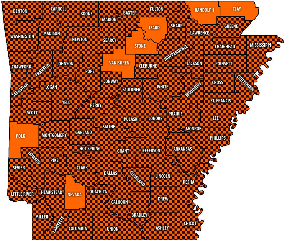
As of Tuesday afternoon, burn bans continue in Boone, Carroll, Madison, Marion, Newton, and Searcy Counites. All but seven counties around the state have burn banks in place according to the latest map from the Arkansas Department of Agriculture.
The continuing restrictions come as prolonged dry weather has increased wildfire concerns across Arkansas. County burn bans generally restrict outdoor burning, and residents should check with county or local officials because restrictions can be imposed or lifted quickly.
The current conditions also have impact water levels. The effects of the dry spell are especially apparent along the Buffalo National River. Current regional water information described conditions at its five monitored locations as ranging from low to very low, with some readings showing only a few cubic feet per second of flow. The Ozark Mountain Region water-level report, based on U.S. Geological Survey data and presented daily on Harrison's Original KHOZ 94.9 and New Country 1029, classified overall Buffalo River conditions as very low.
Those conditions can make floating difficult or impractical on some stretches, with shallow water and exposed gravel bars becoming more common. Conditions can vary considerably from one section of the river to another. During a recent edition of the Conservation Report on the Branson Podcast Network, Missouri Agents report similar conditions on Missouri Streams though some streams like the James River still have some floatable areas due to water moving between Lakes Springfield and Table Rock Lake.
Bull Shoals Lake is also below its normal conservation pool. The lake stood at 655.12 feet above mean sea level early Tuesday, Sept. 22, approximately 3.88 feet below the 659-foot full pool elevation. The lake had changed only about three-hundredths of a foot from the previous day.
Regional data also showed Bull Shoals trending downward during the weekend. The same general trends have been observed on Table Rock Lake.
The combination of widespread burn bans, very low water flows and falling reservoir levels provides several signs of the continuing dry conditions across the region. While the larger reservoirs remain usable, boaters should be more alert for shallow areas, particularly near shorelines, ramps and normally submerged obstacles as water levels decline. River users should check current gauges before beginning a float trip because conditions can change significantly with rainfall or dam operations.
More information on outdoor conditions can be found on the At Your Service Podcast on the Branson Podcast Network.
 New Bridge over Flat Creek Complete, Highway 248 Open
 Forsyth Begins Process of Repairing Damaged Fire Station
 Law Enforcement Seeking Information on Deadly Beaver Lake Accident
 Murder Suspect Arrested in Lakes Region Identified


